HysIS (Hyperspectral Imaging Satellite)
HySIS (Hyperspectral Imaging Satellite) is an Earth observation satellite launched by Indian Space Research Organisation (ISRO). Hyperspectral Imaging Satellite provides images that are utilized for various purposes ranging from agriculture to deference.
What is hyper spectral imaging?
Human eye recognizes colour of visible light mainly in three bands. Eye identifies long wavelengths as red, medium wavelengths as green and short wavelengths as blue. In spectral imaging, light spectrum is divided into many more bands and even extends beyond visible light. Hyperspectral imaging combines the powers of spectral imaging and digital imaging. Hyperspectral imaging gathers and processes information across entire electromagnetic spectrum. Hyperspectral imaging captures spectrum of each pixel so that the technology can be employed for finding and identifying objects and materials. This method is employed by scientists and researchers in various fields like astronomy, molecular biology, advanced studies in physics, biomedical imaging etc. Hyperspectral imaging has become a trend across the globe, though it is still in the evolving stage.
HysIs Mission by ISRO
HysIS along with thirty other satellites (one micro -under 100 kg- and twenty nine nano- under 10 kg- satellites) from eight different countries was launched by ISRO on a PSLV-C43 satellite launcher. It was the 45th flight of Polar Satellite Launch Vehicle (PSLV). The primary payload of PSLV-43 mission was HysIS and of the total payload of 641.5 kg, 380 Kg belonged to HysIS. Commercial arm of ISRO, Antrix Corporation Limited, carries out commercial launches for other countries. All satellites were placed in orbits successfully. HysIS was released into an orbit at 636 Km.
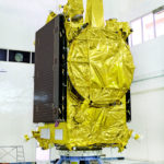
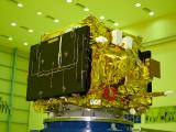
Hyperspectral Imaging Satellite (HysIS)
HysIS is the first hyper spectral imaging satellite launched by India. It was indigenously developed by ISRO and can be utilized for advanced Earth observation. The images from HysIS will be helpful for the country for advanced studies and researches in various fields like agriculture, defense, forestry, coastal zones, soil survey, geology, pollution detection, environmental monitoring, waterways etc. Major focus of HysIs is studying the earth’s surface in visible near infrared and shortwave infrared regions of electromagnetic spectrum. This covers visible, near infrared and far infrared bands of spectrum, within a bandwidth of f 400nm-2500nm wavelength.
HySIS has two payloads, the first in the Visible Near Infrared (VNIR) spectral range of 0.4 to 0.95 micrometers and the second in the Shortwave Infrared Range (SWIR) spectral range of 0.85 to 2.4 micrometres. It is expected to be in service for five years. The heart of Hysis, the optical imaging detector chip, was designed by Space Application Centre of ISRO. It was fabricated by ISRO at it its semi-conductor lab at Chandigarh.
What is the Square Kilometer Array (SKA) project?
Why is the Hubble Space Telescope (HST) famous?